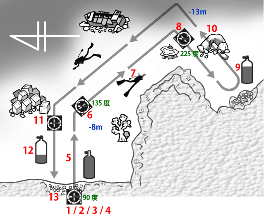
1 |
Choose a shore-entry dive site with a gentle slope and a maximum depth of about 10 m. Start at the entry point. |
2 |
Hold the compass level and point the direction-of-travel line offshore. |
3 |
Rotate the bezel until the north end of the needle is aligned between the index marks. |
4 |
Record the bearing shown by the compass. |
5 |
After you descend, keep the needle aligned and swim to an area where the terrain changes noticeably. |
6 |
At each turn point, aim the direction-of-travel line in the new direction and record the depth, terrain features, natural landmarks (including marine life), and your bearing. |
7 |
Follow the new bearing and swim to the next area where the terrain changes noticeably. |
8 |
At the next turn point, repeat Step 6 and record your observations. |
9 |
Turn the dive when you reach two-thirds of your starting gas supply. |
10 |
On the return, continue recording additional terrain features and natural landmarks. |
11 |
To navigate back to the exit, follow the reciprocal bearing. (The south end of the needle aligns between the index marks.) |
12 |
Begin your ascent when you reach one-third of your starting gas supply. |
13 |
Your memory map is complete. |