
Easy Diving with Navigation
Certification Card
Types of Navigation
Surface Natural Navigation
Surface Compass Navigation
Underwater Natural Navigation (1)
Underwater Natural Navigation (2)
Underwater Compass Navigation (1)
Underwater Compass Navigation (2)
Underwater Compass Navigation (3)
Underwater Compass Navigation (4)
Underwater Compass Navigation (5)
|

|
|
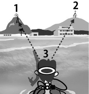
A method of determining your approximate surface position by aligning visible coastal landmarks is called using transits or range marks in navigation terms.
Distinct shoreline features such as buildings, chimneys, small islands,
moorings, piers, or prominent natural formations can serve as reference points.
At familiar dive sites, these landmarks make it easier to identify your position on the surface.
|
-
Select two clearly visible landmarks that are as far apart as possible
and align them from your position (for example, a palm tree and a building on a hill).
-
Choose another pair of visible landmarks, also widely separated,
and align them from your position (for example, a hotel and a church tower).
-
The intersection of these two alignment lines determines your approximate surface position.
|
|
|
|
For greater accuracy, ensure that the two landmarks forming each line
are widely separated and that the two alignment lines intersect
as close to a right angle as possible.
|
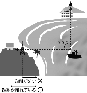
Select landmarks that are clearly separated, such as a palm tree and a hilltop building.
|
|
|


|
|