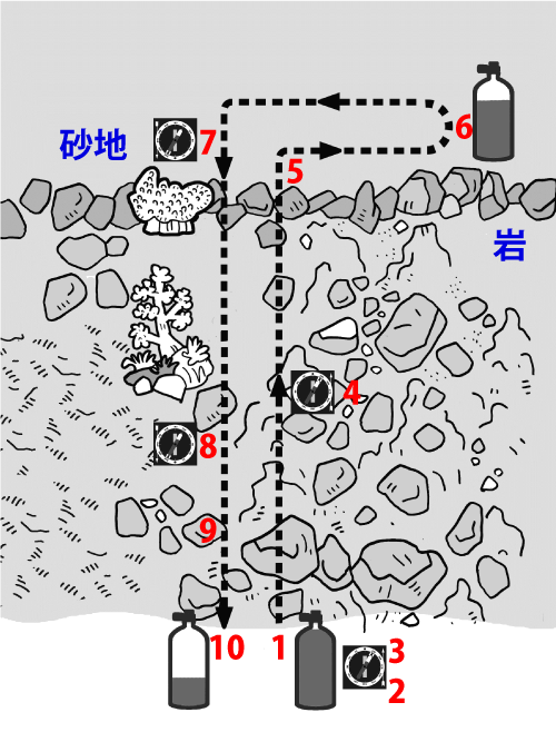
1 |
Choose a dive site where the bottom slopes gradually
and the maximum depth offshore is about 10 m.
Stand at the shoreline entry point.
|
2 |
Hold the compass correctly and align your body
so the lubber line points offshore.
|
3 |
Rotate the bezel so that the north end of the magnetic needle
is positioned between the index marks.
|
4 |
After entry and descent, swim straight while keeping the needle aligned
between the index marks and following the lubber line.
As you swim, choose an object in the correct direction (a rock, coral, etc.)
and swim to it without constantly staring at the compass.
Check the compass periodically.
|
5 |
When you reach a major terrain change (for example, the boundary between rock and sand),
change direction and swim along the boundary.
Memorize the features at the turn point (terrain and marine life)
so you can recognize it on the way back.
|
6 |
When your remaining air reaches the first 2/3 point
(turn pressure), begin your return by following the boundary in the opposite direction.
|
7 |
When you return to the turn point, rotate your body until the south end of the magnetic needle
is positioned between the index marks.
|
8 |
Keep the needle aligned between the index marks
and swim straight while following the lubber line.
|
9 |
When your remaining air reaches the first 1/3 point,
begin your ascent.
|
10 |
Confirm that you have returned to your original starting point.
|