
Easy Diving with Navigation
Certification Card
Types of Navigation
Surface Natural Navigation
Surface Compass Navigation
Underwater Natural Navigation (1)
Underwater Natural Navigation (2)
Underwater Compass Navigation (1)
Underwater Compass Navigation (2)
Underwater Compass Navigation (3)
Underwater Compass Navigation (4)
Underwater Compass Navigation (5)
|

|
|
When there are no distinctive coastal features available,
you can determine your approximate surface position
by using a sighting compass.
Use a compass that is waterproof and designed for marine use.
|
-
Select one visible landmark on the coastline (for example, a palm tree)
and take a compass bearing. <Figure 1>
-
Select a second visible landmark (for example, a hotel building)
and take another compass bearing. <Figure 2>
-
Plot the two bearing lines.
The intersection of these lines determines your approximate surface position.
|
|
For greater accuracy, ensure that the two bearing lines intersect
as close to a right angle as possible.
|
Sighting Compass
|
|
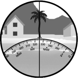
<Figure 1>
Palm Tree
|
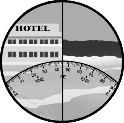
<Figure 2>
Hotel (Edge of Building)
|
|
|
|


|
|